Public record · civic memory · regional context

Seattle ChronicleHistorical record & civic resource

A curated reading room for Seattle’s public life and changing cityscape.

Places & culture · map record

Maps and photographs for reading Seattle’s landscape.

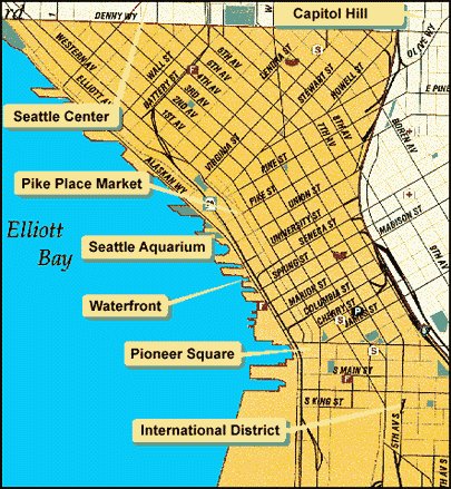
This resource guide gathers geographic references, route maps, virtual tours, demographic material, and photographic collections. Use it as a historical index, and check the date and source of each linked resource.

Ferry crossing gray water beside a wooded Seattle-area shoreline
Water, roads, neighborhoods, and public spaces form the map of regional life.

resource guide ·

Geography is more than a route from one place to another.

Maps preserve how a city describes access, movement, services, neighborhoods, recreation, and regional connections. The references below retain the broad structure of the original civic index while presenting it as a dated reading list.

Some older links may no longer provide current instructions. Treat them as historical references and confirm active services through current official sources.

Folded map and compass arranged on a wooden table
Maps are records of priorities, boundaries, movement, and public access.

02 · Virtual tours

Explore through recorded views

Tour pages connect geography with memory, ecology, public works, and the experience of moving through the region.

03 · Mapping services

Reference collections beyond one city

These preserved links point toward map libraries, environmental references, public geography, and general atlases. Availability may vary.

04 · Demographic information

Numbers help locate a community in time.

Demographic pages provide context for population, regional identity, and planning. Because datasets and definitions change, older pages should be read as dated reference material rather than current statistics.

05 · City photo collections

Photographs as civic evidence

Images record buildings, public facilities, shorelines, working landscapes, and everyday city life. The collection below keeps those subjects grouped for further reading.

06 · resource method

How to read an older map or image link

Preserved resources are most useful when their original purpose and date remain visible. Follow the source, note the terminology, and avoid treating an old map as a current service guarantee.

  1. Identify the subject

    Decide whether the page concerns transportation, property, recreation, planning, demographics, or cultural history.

  2. Check the date and context

    Names, routes, departments, and data definitions may have changed since publication.

  3. Compare the geographic scale

    Distinguish a neighborhood reference from a city, county, state, or national collection.

  4. Confirm active information elsewhere

    For present-day directions, closures, safety, or services, consult current official sources.

Reader’s desk

Questions about the map index

A short guide for using this page as historical reference.

Are these maps current?

Not necessarily. This page preserves a dated index of map and photo references. Check every source’s date before relying on it.

Why include external collections?

Seattle’s geography and history extend beyond one institution. Regional, library, environmental, and cultural collections add useful context.

What does “virtual tour” mean here?

It refers to preserved tour pages, interactive references, and image-led guides that help readers explore a place without treating the page as a current travel instruction.

Can I use an old map for directions?

Use it for historical orientation only. Roads, transit, access rules, and public facilities can change.

How can I report a page-reference issue?

Send the page title, link, and a brief description to the resource contact.

resource desk

Find another preserved subject

Search by a place, service, collection type, neighborhood, or public topic.